Sunday, December 29, 2013

Happy Holidays!

In honor of the celebrations of Christmas and the New Year, here is a short clip from Almaty's Christmas tree lighting party a few weeks ago.

Merry Christmas everyone and a very happy New Year!


Sunday, November 3, 2013

A Wild Week in Tajikistan's Fann Mountains

Iskanderkul Lake, Tajikistan
Shall I say right off to prepare for a rather long story about the amazing (and wild) world that is Tajikistan?

Saturday afternoon a friend and I flew to Dushanbe where we were met at the airport by our guide, Miskala, the owner of Orom Travel who had responded to our last minute request for a guide and driver with amazing speed and willingness to accommodate.  After a filling Indian meal at Namaste-Salaam, we began the drive from Dushanbe to Iskander Kul under grey skies.  By the time we reached the third and final toll booth before the ascent to Anzob pass, it was dark, and clouds were spitting rain.  The toll booth attendant told Miskala that it was snowing on the pass and that there was a big traffic jam up there.  After a brief conference we decided to press on.  When we reached the point where the rain turned to snow, we saw what the toll booth attendant meant.  Nearly a dozen big Chinese trucks were stopped haphazardly along a one kilometer stretch of road the drivers outside trying to attach their traction devices on the icy road.  Sprinkled among them was the odd Mercedes sedan, one with a trunk piled full with rocks in an effort to gain more control.  We weaved in and out vehicles stranded on the ice dodging an occasional Toyota coming down the hill, and with only one scary moment, we inched our way to the top of the hill and the "Tunnel of Death."
Aznob Tunnel ("the Tunnel of Death") Tajikistan

Anzob Tunnel is five terrifying kilometers of darkness and smog.  Apparently unfinished, the interior of the tunnel is some of the roughest road I've ever ridden on.  Once paved but now largely dirt, the way is mined with potholes and left-over construction equipment.  Steel reinforcement bars poke out of the tunnel walls.  Cars zigzag through the through the maze of ruts and potholes their low-beams illuminating the dust and smog that help give the ventilation-less tunnel it's nickname.  After 20 long minutes in the tunnel we emerged on the other side alive, but facing a steep icy descent from the pass. Miskala, for a moment, considered turning around but when we pointed out that either way she'd have to descend an icy road, we pressed forward.  Our Toyota Rav4 inched down the mountain passing cars that had slid into the drainage ditch or nearly off the road. As we dropped in altitude, the snow stopped, and then suddenly, the road was dry.

After another hour on a good road and an hour after that on a rough dirt road, we managed to reach Iskander Kul shortly after 11 pm, four and a half hours after leaving Dushanbe.  We stayed at the camp, a collection of thirty-odd cottages on by the shore of the lake, in a small, freezing cold wood-sided cabin with only one space heater for four rooms.  The night was cold, but the morning was colder - a frigid -6 degrees centigrade.  We breakfasted on a feast of fruit salad, fresh bread, and fried eggs in the glass-sided dining hall before walking around the turquoise lake set among jagged, rocky peaks to the Presidential Dacha and the legendary honeymoon
cave of Alexander the Great before walking through the gorge and then climbing up to an Autumn-gold sub-alpine meadow shaded by rocky mountains thrusting into the deep blue sky.  We followed the meadow to the village of Saratag, and then wound our way through the village, politely declining offers of tea from the villagers, until we were able to see the Great Ganza (over 5,200m in elevation).  After a quick trip to a suspension foot bridge we dined on potato soup and hot tea provided by a generous villager before beginning our walk back to Iskanderkul.

The next day, before leaving Iskanderkul, we took a short, half hour hike to a waterfall, and on our way back scrambled into an old, rusty hand-crank cable car and crossed the river.  After lunch we began the trip eastward to the Seven Lakes.


The road to Panjakent
If there is one thing I've learned about traveling in Tajikistan, it is to always add two hours to the estimated travel time.  After traveling north for nearly an hour the road splits at the town of Ayni.  One road (the nicer road) heads north to Khujand, the other, more of a dirt track made worse by ongoing construction, heads westward through the mountains to the border town of Panjakent.  The
road follows the Zaravshan River through a narrow gorge dotted with tiny villages colored red by the changing leaves of the apricot groves and crisscrossing the river on old one-lane cable suspension bridges. After nearly five hours (of a three hour trip) bouncing along occasionally paved dirt road and detouring through a village (where a young boy exclaimed in surprise "A Woman driver!") to get past a section of the road that is closed for construction. We arrived at our guest house just above the fourth lake just in time for dinner.

The road to Panjakent

Our Homestay
Jimuboi's guest house is of traditional four-bedroom mud construction with hand embroidered wall hangings, wood burning Pichka stoves for heat, and outhouse style facilities.  After the frigid cabin at Iskander Kul, the smokey warmth of the pitchka's was welcome.  The next morning, we drove along past the 5th and 6th lakes and then hiked up the too-rough-to-drive road to the 7th, final lake of the 7 lakes where we pickniked on the pebble beach, walked along the donkey path, used mostly to haul hey down from the alpine meadows, and listened to our guide tell stories of the eight day treks he's guided through these mountains.
Seven Lakes, Tajikistan (the Seventh Lake)

On our way back to the car we stopped in the village under the pretense of finding the school.  The children of the village were more than happy to talk to us and to guide us to the newly constructed school.  The school master let us look around inside and I even showed a couple of the kids how to play the old, dented bugle we found on one of the shelves. As we walked down the hill from the school, we stopped to talk with an old woman carrying an enormous piece of bread.  She explained how the bread was baked under a rock and even gave us a huge piece to try.  After saying farewell to the village children we drove back to our homestay to clean up before dinner.

The next morning dawned grey and dreary.  We drove leisurely back down the valley stopping to take pictures of the first four lakes and at a village to explore it's narrow streets and multi-home compounds before continuing our drive to Panjakent. 

Panjakent Bazaar
We arrived in the border town of Pajakent shortly after noon.  While Miskala arranged lunch, our Panjakent guide showed us around the round food bazaar.  We feasted on green salads and Plov (being vegetarian, I had a version of mac n' cheese made with Lagman noodles) in a cafe next to the bazaar before heading out to the museum.  Panjakent's museum tells the both history of the town and the history of the archeological discoveries of ancient Sarazm and ancient Panjakent.  After seeing the museum, we drove to the ruins of Sarazm and then to see the wall erected at the now closed Panjakent-Samarkand (Uzbekistan) border.  Our guide jokes that it is the "Berlin Wall" separating families from both cities and substantially impacting tourism as people wishing to visit historic sights from both cities can no longer cross the boarder here.  We spent the night in a soviet era Intourist hotel, exploring the nearby tea-house before dinner. 

Panjakent Tea House
Ayni Minaret
The following day was spent entirely on the return journey to Dushanbe. Back along the dirt road, through the deep gorge and over the old bridges and tiny villages.  A quick stop in Ayni to admire a 9th century minaret and to pick up some fresh bread to munch on in the car, and southward.  Back through the tunnel of Death, where it was still snowing but on dry roads this time, back down the valley to Dushanbe.

You've made it to the end of the post!  Congratulations!  Next post will probably be a monster picture post with pics of all the hikes I've taken this fall - unless something more exciting happens first...


Dushanbe, Tajikistan

Saturday, October 26, 2013

The story of the Best Birthday Ever


...in which I complete my first handshake money exchange, drink beer with a politician who could double for Psy, and see stars invisible to the naked eye...


It isn't every year, that your birthday falls on a Saturday, so when it does it's important to seize the moment and do something amazing.  For weeks leading up to the big weekend I had been hatching various forms of a plan all centering around an overnight at the Tien Shan Astronomical Observatory high up in the mountains above Big Almaty Lake.

As my birthday morning dawned, though, I still didn't have anything settled.  Calls to the observatory number listed in the Lonely Planet Guidebook had been unfruitful, and as two friends and I began the drive to the Big Almaty Lake with no reservations at the observatory and no clue as to the protocol for spending the night, and no native speaker of Russian in our midst, I was prepared to have to find a place to camp.

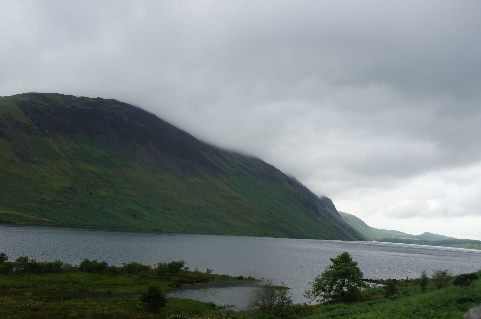
The road up the Big Almaty River gorge narrows to something just over one lane wide as it winds up the steep, pine covered gorge walls.  From time to time, it widens to allow for cars to pull off and admire the impressive views.  As we approached the top of the gorge, we found the way blocked by a red gate with peeling paint and a police car. As we pulled up to the location, the police officer showed no sign of moving toward us and I noticed that a half dozen other cars were parked in the narrow strip of gravel beside the road outside the gate.  I got out of the car and approached the police officer.

"I'm sorry, I don't speak Russian very well," I began.  I often begin negotiations in Russian with that expression because it usually improves my chances of understanding what is said to me as people choose simpler language than they might otherwise use.
"We are going to the Astronomical Observatory, can we enter?"
The police officer responded with some kind of explanation that completely escaped my entire Russian vocabulary but amounted to "no."
"Is it possible to drive to the observatory?" I asked
"Yes it is possible" the officer responded. 
"Is the road good?" I asked, thinking perhaps our car wouldn't make it.
"Yes, it is very good" the officer responded.
"So can we enter?"
Once again the officer strung several sentences together that entirely escaped me.
"I'm sorry," I said somewhat sheepishly "I don't understand."
The officer looked at me for a second and then sighed in exasperation,
"Alright, 2000tg and you can go,"
"Just a sec," I said. I returned to the car to report and get money.
As I returned to the officer with the gratuity, another man was approaching him.  The officer and I shook hands as he opened the gate to let us through.


The road climbed to the top of the dam before turning to the west and climbing to the plateau that is home to the collection of buildings that make up the observatory, we parked and then began looking around the buildings for any signs of life.  Inside a long, pink stone building with an atrium peeling paint and lecture seats lining the walls we found Nelly working in the Kitchen.  Nelly is an old woman with short grey hair dressed in camouflage pants, combat boots a sweater and a black beanie.
"I'm sorry, I don't speak Russian very well," I began once more, "do you know where I can ask about sleeping here tonight?"
"We have space, but no food.  How many people?" she asked curtly.
"Three people," I reply.
"Three thousand five hundred for each person and one thousand for the tour."
"Three thousand five hundred..." I began to repeat when she interrupted.
"Three thousand five hundred for you, three thousand five hundred for her, three thousand five hundred for him, but there is nothing to eat" Nelly said with a large gesture at each of us as she explains.
"Very good."  I reply. "Who do we pay?"
"You can pay me. Do you want some tea? You can go hiking and when you return, Tea, and then you can pay me."
"very good" I replied.


Nelly lead us back though the entry and down a narrow hallway before turning through a doorway that lead to a suite of four rooms with a bathroom and washroom.
"So," she said opening one of the rooms, "you can sleep two in here and one in here, or two in here and one in here or two in here and one in here, or if you want, two in this room and one in that one."  She had opened the doors to each room as she spoke, showing us our options. When my friends and I quickly chose two rooms to suite our fancy, Nelly said "just lock the door and take the key and they will be yours.

After settling in at the observatory, my friends and I decided to hike up to Kosmostansia, an ionosphere laboratory that sits 3346 m above sea level at the top of a ridge that connects Big Almaty Peak with the Turist peak.  While there is a paved road, we opted to take the trail, which ended in us climbing up a very steep grassy slope.  The view from Kosmostansia was phenominal and as we sat atop the chilly ridge breathing the fresh air and looking at the paths that lead to the summits of the two peaks the world was still and peaceful.

On our way out of the Kosmostansia facility, we encountered a black SUV with four gentlemen who had just brought out a two liter bottle of beer.

"Where are you from?" one of the men asked in Russian as we passed.  We stopped,
"From America," we answered.
"AMERICA!!!!" The four men yelled in unison.
"Do you want some beer?" One of the men asked, I looked to my friends
"Sure," they answered, "thank you."
We made general introductions as one of the men poured.
"look, look," said one of the others as he pointed at one of his friends, "Gangnam style!"
Sure enough, with sunglasses on, the man was a dead ringer for Psy.  We all laughed.
"They all promised me there would be snow up here,"  The man said reprovingly,  they promised me that I would be able to hold snow today, but no snow.  Just cold."

"What kind of beer is this?" I asked Mario, the man who'd been pouring the beer.
"It's just one of our local beers?" he replied.
"Not Chemkentskaya? I've heard that is the best." I said and an approving roar went up from the group.
"These two are from Shymkent," Mario explained as he took a smoked fish, broke it in half and began handing everyone a small piece. "For us Shymkent is like Texas..." Everyone laughed.
"Cheers."

We stood on the darkening road drinking beer, eating smoked fish and talking for about 20 minutes when Psy explained that he had to get to the airport and asked if we wanted a ride down the mountain. The next thing I knew, Lina was on my lap in the front seat, and Jack was squeezed into the back with Psy and two members of his entourage as Mario drove us down the narrow, winding mountain road to the observatory.


As we entered the observatory I found Nelly and asked if we could use the kitchen to kook some food.
"Yes of course" she answered.  "Tea?" she asked.
"Yes please" we all chimed.  Tea sounded really great after our climb.

We talked and sipped tea as our dinner of lentil and vegetable soup simmered in Nelly's Kitchen. Just as we finished Nelly told us we should go look at the stars now. She hurried us out the door but not before sending us back to our rooms several times to get warmer layers for the night air.  By the time we reached the little aluminum domed structure that houses the telescope the tourists get to use, a tour was already in progress.
"Come back in two hours," the telescope operator told us.
"Two hours!" we said with a fair amount of disbelief.
"Maybe one hour" he replied.
"OK" we said and the took a walk around the dirt roads that connect the many wooden and cement buildings of the facility admiring the night sky, isolated from the light pollution of Almaty by the towering peaks on all sides.  After about forty minutes we returned to the telescope and found it ready for the next group.  again and again, the guide casually positioned the telescope to point a an empty bit of blackness in the star-streaked night sky and then invited us one by one to look through the eye piece at a star cluster containing more than 300,000 stars, a double star, a dying star, and other wonders of the universe that are invisible to us for the vast majority of our lives.

That night I dreamed of stars and as we woke, breakfasted, packed, and took a farewell walk around the lake, I basked in the afterglow of the best birthday I could have ever wished for.

I'm off to Tajikistan, I'll have more stories and pictures from my fall hikes soon.

Sunday, August 11, 2013

UK Part IV: Scotland


The final part of our trip to the UK was in Scotland and mostly in Edinburgh.  On Tuesday we traveled from Penrith station in the Lake district up to Ediburgh.  The train was only three cars long, and this being the middle of "the Festival" (The Edinburgh Fringe Festival along with several others), the train was standing room only.  I passed the trip along with seven other people and at least ten suitcases standing by the doors.  Just when I thought no one would even think about trying to get on at our door, a family with a young mother, her seven or eight year old daughter, a large suitcase, and a stroller with an infant climbed in as the rest of us frantically tried to rearrange the suitcases that filled the area in order to accommodate them.


Edinburgh is an inspiring city.  For me, the fun is walking and exploring the old streets lined with centuries old brown and grey stone buildings perforated with tiny Wynds, Closes, and Courts - tiny pasages that connect streets and lead to gardens.  The small museums are also fun, the Writers' Museum (in Lady Stairs Close) with it's narrow spiral staircase and second floor balcony and displays on Scott, Burns, and Robert Louis Stevenson was probably my favorite place in the city.

Tuesday night we attended the Scottish National Royal Military Tattoo, a display of music and culture outside the castle.  While occaisionally so cheesy it was groan worthy, the technical and musical displays were amazing.  Groups from New Zealand, Korea, Mexico, and Mongolia performed along with the Royal Scottish Pipes and military band.


The Highlands
Wednesday we took a monster bus trip through the highlands.  We spent more than twelve hours on a coach bus listening the the Scottish tales of our bus driver, Peter, who never mentioned Mary Queen of Scots without the phrase "Our Tragic Queen" and told tales of the McGregors - Children of the Mist,  and of the Massacre of the Glencoe MacDonalds (as we drove through Glencoe).  We got off at Loch Ness to explore the ruins of the Urquhart Castle on the shores of Loch Ness and to ride across the Loch to meet the bus again at Inverness.


Thursday and Friday I spent in Edinburgh, exploring the city and partaking in little parts of the Free Fringe.  The Fringe Festival and the Free Fringe bring thousands of actors, comedians and musicians into town, and for a donation (or not) you can buy a beer at almost any old city pub and catch a comedy act at almost any time of the day.  Street acts fill High Street and Grassmarket, some of them are high school or college vocal ensembles in Scotland to perform at the Fringe, others are comedians cutting their teeth.  One balloon sculptor would throw a rubber chicken at people who walked away from his act.  An australian comedian and unicycle rider would introduce passersby as his "Father," ("that's not mum, dad"), agent, ex-wife ("it's over, honey") and drug dealer. He had the crowd in stitches as he waved at every passing tourist bus and invited participation from the crowd and those who walked by - all of this before he got on his 9 foot unicycle and juggled fire.


Wednesday we took the train over to St. Andrews, to see the Golf Course and the beach from Chariots of Fire fame (yup, that's pretty much the only reason we went).  While there, we also enjoyed the sights and delicious tastes of a summer fair complete with amusement rides, fish and chips, and Ice Cream.


Now we resume our trip, returning to london by train (this time not overbooked).

P.S.  When in Edinburgh, beware of bedbugs

Friday, August 9, 2013

UK Part III: The Lake District (continued)


Ambleside
Morning at the Robinson Place Farm B&B in Langdale brought a full English breakfast with eggs, bacon, sausage, mushrooms, tomatoes, and toast along with periodic showers interspersed with bright moments of sunshine.  We had arranged to take a day off of hiking for our second day and so after a leisurely morning taking advantage of the internet connection at Robinson Place Farm, we set out for a slow stroll to Grasmere - a charming town about four miles from Langdale. We strolled along the country lanes following the directions Google provided to us until we arrived at a town that was not Grasmere.  We'd walked all the way to Ambleside - nearly six miles from Langdale.  As it turns out Ambleside has buses that run out to Dungeon Ghyll, so even though we walked a lot farther getting there, we didn’t have to walk back.  We lunched, strolled, sourvenir shopped, ate ice cream, and took photos of the old English buildings of Ambleside before catching the bus back to Dungeon Ghyll.

When we woke up for our day of hiking from Langdale to Wasdale head, threatening dark clouds blanketed the valley we were to hike up.  A park ranger stationed at our trailhead behind the Old Dungeon Ghyll Hotel told us to expect rain from 10 to 12 and from 4:00 on.  We’d already decided to take the low route today and not go up Scafell pike, but the ominous forecast reinforced our choice.  As a precaution against sudden showers, I wore my raincoat, and pulled an orange rain cover over my day pack.

the view back toward Langdale
We walked up the valley along the Langdale portion of the Cumbria way trail with the threat of rain always ahead.  Along the way we met a German gentleman who was taking his teenage kids up Scafell pike.
“I walked this exact same trail twenty years ago,” he informed us.
"can you see us here in twenty years?!" my friend Joanna asked us.

Angle Tarn
After a couple of miles of loose stone trail on the valley floor the path crossed a small stream, and began climbing.  This portion of the trail is a recently restored packhorse trail.  This means stairs lots and lots of stone stairs that lead to the saddle between Rossett Pike and Hanging Knotts.  We climbed and climbed, and even though the sky retained it's ominous grey hue, the rain didn’t fall. We paused for lunch on the banks of the black waters of Angle Tarn before climbing more stone stairs to a cross-wall shelter (a stone wall built in the shape of a cross to provide shelter from the wind for travelers along the path) and the highest point of our low route hike.  From the shelter, we could see across the valley, across Langdale Pike all the way to Ambleside. 

Ambleside is at the end of the large lake you can see in the distance
At this cross wall shelter, the high path to the top of Scafell Pike breaks from the lower route down to Sty Head Pass.  We chose the lower route and followed the little gully that held Ruddy Beck downhill to Sprinkling tarn, and then to Styhead Tarn and Styhead pass.  From the pass we could see into the next valley down to the little collection of white buildings that make up Wasdale head.  And as we reached the bottom of the steep loose-stone path leading off Styhead pass, the heavens final opened and the rain came.   

Wast Water in the rain
Wasdale Head is a little community near the shores of the lake called Wast Water.  It is famous for it’s proximity to the great mountains of Scafell pike and Great Gable and for St. Olaf’s church (the smallest church in England with a cementary that is home to those who lose their lives climbing the surrounding mountains).  The town consists of a Hotel, a bed and breakfast, a sporting goods and general supplies shop, a pub, and nothing else unless you count sheep.  It only took us a couple of seconds to find our way to the Bed and Breakfast housed in an old vicarage where we were to spend the night.

Mud and Clouds at Styhead Tarn
Stairway in the clouds
The rain fell through the night and we knew we were in for a wet walk.  Since our guide strongly cautions against attempting to climb Great Gable (the high route) in bad weather, the low route was the way we were going. In the overnight rain the tiny springs that had trickled down between the stones in the path had grown to full-fledged brooks and streams that not only rushed across the path, but often used the path as their riverbeds.  As we climbed into the clouds that obscured the mountains, I was increasingly grateful for a good rain coat and a good pair of boots.  With the reduced visibility and the added challenge of crossing the many streams and torrents on the path it took us a bit over two hours to reach the top of Styhead pass. As we headed north along the edge of Styhead Tarn and along the now raging Styhead Gill (a gill is a  river).  Our trail wound down the hillside, sometimes disappearing entirely under the current of the bucking white water forcing us to pick our way across the stony, and sometimes boggy, grassy hillside.

Crossing Stockley Bridge
There is only so much a pair of boots can do to hold out the weather though, and all of the wading through torrents of water rushing down the mountainside began to take its toll as water worked its way into my boots and condensation built up on the inside of my rain jacket.  As we descended into the valley, I was beginning to feel a bit water logged. When we reached the valley and crossed the old stone Stockley Bridge we still a long way to go.  We walked for more than an hour through endless stone-walled pastures passing through at least a dozen gates.  Water, now in the form of deep puddles still obscured the path and often the only way through a gate was to wade through a deep stretch of water. We crossed the road and “Folly Bridge” and made our way in along a wooded path next to the River Derwent until we came to a place where the path was blocked by a large rocky protrusion that reached out into the rapids of the brown water.  We picked our paths through the rocks, trying not to look at the raging river crossing a slab of rock with the help of a chain attached just above a natural crack across the slab.

Past the youth hostel and across another field, it was less than a mile to the Royal Oak Hotel.  The Royal Oak Hotel – the perfect ending for a marvelously wet day walking along the fells and among the peaks of the Lakes. The Royal Oak Hotel and their warm inquiry as we walked in “tea and scones?” Yes please!

Next up: Scotland…well, Edinburgh anyways.

Tuesday, August 6, 2013

UK Part III: The Lake District


My friends and I arrived at Penrith train station at 10:35 in the morning.  Between the four of us, it didn’t take long to arrange for tickets to Edinburgh find the bus schedule for the busses from Penrith to Keswick (pronounced Kezik), and chat with a teacher from Lacashire who teaches 17 7-9 year olds in one classroom and was going to Keswick for a convention.  The bus to Keswick only leaves once every hour, but the bus from Keswick to Rosthwaite – the start of our walking trip – leaves every half hour and it is only a 15-20 minute ride between the two communities.


We stepped off the bus in Rosthwaite next to a stone wall bordering a field.  There was no walk, or footpath to speak of and the road was just barely large enough for one lane of traffic.  We walked down the road and ducked into a narrow alley to check for directions to the hotel.  There were no directions.  The day was rapidly turning into my kind of adventure.  We walked along the alley as this seemed like a one-alley, stone-cottage kind of community. At the end of the alley we came to the Flock-In tea house, but no hotel.  It was time to ask for Directions.  We asked two gentlemen enjoying a pint in the patio of the little stone-cottage bed and breakfast in an adjoining alley.

“I’m not sure” one of them said, “Let me ask someone who might know.”  He got up and went inside the little house.  A couple of minutes later a woman came out. 

“What are you looking for?” She asked in the almost Scottish lilt that is characteristic of this area.

 “We’re looking for the Royal Oak Hotel.” I replied.

“That’s over in Rosthwaite.” She said.  “you go right to the end of this road, turn right on the next one, go to the end of that road to the main road and there’s two hotels there, you’ll see them right there.”

For a brief moment I felt like an idiot.  The directions she gave us were back along the alley we came up, and we didn’t see any hotels when we turned up from the main road.  Nevertheless, when we arrived back at the main road, just beyond a narrow spot created by the corners of two stone building, stood the Royal Oak Hotel.


Any discomfort we may have experienced in our momentary inability to find our accommodations and walking trip start-point was quickly dispelled by the warm welcome given us by Neil when we rang the bell.

“Tea and Scones?” he asked once he’d given us our room keys and made dinner arrangements for us.

“Perhaps in a bit.” We replied.


We spent the afternoon getting organized for our first day hiking, reading the guide, studying the map, arranging for a hotel packed lunch with Annie, packing our day-packs, and finally, “dressing for dinner” (as best we could given our limited travel wardrobes).


Dinner at the Royal Oak Hotel in Rosthwaite is quite an affair.  Soup, main course, and desert, and a comprehensive wine list and full bar was far more than I’d imagined when Neil made the arrangements for us.


 Leg I: Rosthwaite to Langdale – The high route via Dungeon Ghyll


Our path started out heading south-east along the famous “Cumbria Way” trail.  Sheep dotted bright green pastures bordered by loose stone walls shot up the hillside to our left as Stonethwaite Beck (a beck, by the way, is a stream or river running through a valley) bubbled away on our right.  I found myself grateful for my gortex lined boots right away as the tiny streams coming off the fells.  A “fell is elevated ground  flooded across the stone path. I found The ridges and rocks of the Barrowdale Fells on our right and Greenup Edge on our left gradually became more pronounced.


At Smithymire Island, our way diverged from the Cumbria Way path and led upwards toward Greenup Edge.  The higher we climbed the more challenging the trail grew eventually turning into a steep scramble up the rocks leading to Lining Crag - a blustery stone outcrop with beautiful views of the green valley we’d just come through.  We huddled down among the rocks for some protection from the wind and munched happily on our enormous packed lunches.

From Lining Edge we continued our upward track to Greenup-Edge on a better trail, and from their climbed our way to the Low White Stones, the High White stones, then across the boggy highlands to the summit of High Raise (762 m).


Cairn (man made pile of stones) at the top of High Raise
After a short huddle in the wind shelter constructed of a short storm wall where we chatted with two gentlemen also on their way to Langdale, and consulted our instructions and map, we set off again.  As the gentlemen (a good deal faster than we were) slowly faded into the distance, the path grew boggier and finally disappeared altogether. I pulled out my compass and attempted to guide us in more or less the correct direction while looking for markers for the path to Dungeon Gill.  I again found myself grateful for a good pair of boots as more than once I stepped into boggy muck that rose to my ankles before relinquishing its hold with a satisfying squelch.   

As we reached the top of a rise of whitish stones, I noticed a group of hikers a short distance below.  I trotted down the stone-speckled grassy hillside to catch them.

“Hello” I said to the first hiker, youngish a middle aged, thin man in brown trousers and a pullover sweater.

“Hi” He replied.

“Excuse me I said, - my friends and I are having some trouble locating the trail to Dungeon Ghyll.  I was wondering if you happened to know that trail.

“I’m sorry, I have no Idea, you should ask Ian, our guide.” He said, indicating another man a few meters off.

“Thanks.” I said, as I turned toward Ian.

“Where are you heading?” Ian asked,

“Dungeon Ghyll” I replied, “we lost the path in the bog.”

“Yeah, the path gets a bit…ambiguous up here.” He replied. “What you want to do is head around those rocks over there and the path should become clear once you get round to the other side.”

“Great, thanks so much!” I said, then turned and bounded back up the hillside with energy that surprised even me.  For a brief moment, I felt like Lizzy Bennett running her cares away in the English Countryside.


I related the news to the others and we began heading in the direction of the mound of rocks that Ian indicated.

“If we find the trail on the other side of these rocks, I’m going to sit down and celebrate with some M&M’s” I told Amy. “And if we don’t find the trail on the other side of these rocks, we’ll first look on the other side of those rocks, and then, at the moment I’m most frustrated, we’ll sit down and have some M&M’s because the world always looks better when you’ve eaten some M&M’s.


When we reached the rock, a rock trail appeared, almost as if by magic.  True to my word, we sat down and took a few moments to munch on M&M’s and trail mix before beginning down the trail.  As a wise young woman once observed: “food always tastes better in the out of doors,” and those M&M’s tasted heavenly.


Stickle Tarn


Stickle Ghyll
The trail down the mountain was more challenging than the description in our guide made it sound.  It was steep and the scree that covered the trail in so many places made it difficult keep footing.  There were many places where we had to scramble, to sit and slide, or to hug the cliff wall in order keep our footing.  Every 50 meters seemed to take an eternity and by the time we reached Stickle Tarn (a tarn is a mountain lake or pool formed in a hollow formed by a glacier) and started down the stairs, my muscles and mind were both tired from the effort.  

 Perhaps at this point in the story it might be worth mentioning that we never actually found the path down Dungeon Ghyll.  Dungeon Ghyll is a steep and deep ravine that hides a stunning water fall.  The path we found also led to a spectacular cascade of water, but this cascade is called “Stickle Ghyll” (a ghyll by the way is a stream or narrow valley containing a stream).  The path we were on, however matched the description in our guide to the letter, and fortunately ends at the same point as the Dungeon Ghyll path.  

About 100 meters into our descent of Stickle Ghyll the trail seemed to disappear.  At almost the same moment, I noticed a parallel trail that seemed to be in better repair running along the other side.  I mentioned this to my companions and they pointed out that several people had crossed the cascade.  At that same moment, we watched two hikers descend to the cascade, step from rock to rock in the raging torrent to reach the trail on the opposite side.

“So we can climb up and cross the dam, or we can try to cross the waterfall.” The vote fell to the waterfall. And so, one by one, we stepped across the slick, wet stones of Stickle Ghyll to the path on the other side.


Waterfalls at the bottom of Stickle Ghyll
The rest of the descent was a blur.  We reached the bottom, followed the directions in our guide to the hotel, discovered we’d been booked at a different hotel (a mile and a half back down the road we’d just walked).  Ate dinner at the Old Dungeon Ghyll Hotel, and walked back down the road to the Robinson Place Farm B&B where we were greeted by Vicky who had these words of warning: “you’ll have to dook. If I see big red marks across your forehead in the morning, I’ll know ya forgot to dook.”  So with, tired muscles, bellies full of English pub food, and Vicky's warning ringing in our ears, we went to bed.

The little white house is the Robinson Place Farm B&B
...To be continued.