My friends and I arrived at Penrith train station at 10:35
in the morning. Between the four
of us, it didn’t take long to arrange for tickets to Edinburgh find the bus
schedule for the busses from Penrith to Keswick (pronounced Kezik), and chat
with a teacher from Lacashire who teaches 17 7-9 year olds in one classroom and
was going to Keswick for a convention.
The bus to Keswick only leaves once every hour, but the bus from Keswick
to Rosthwaite – the start of our walking trip – leaves every half hour and it
is only a 15-20 minute ride between the two communities.
We stepped off the bus in Rosthwaite next to a stone wall
bordering a field. There was no
walk, or footpath to speak of and the road was just barely large enough for one
lane of traffic. We walked down
the road and ducked into a narrow alley to check for directions to the
hotel. There were no
directions. The day was rapidly
turning into my kind of adventure.
We walked along the alley as this seemed like a one-alley, stone-cottage
kind of community. At the end of the alley we came to the Flock-In tea house,
but no hotel. It was time to ask
for Directions. We asked two
gentlemen enjoying a pint in the patio of the little stone-cottage bed and
breakfast in an adjoining alley.
“I’m not sure” one of them said, “Let me ask someone who
might know.” He got up and went
inside the little house. A couple
of minutes later a woman came out.
“What are you looking for?” She asked in the almost Scottish
lilt that is characteristic of this area.
“We’re looking
for the Royal Oak Hotel.” I replied.
“That’s over in Rosthwaite.” She said. “you go right to the end of this road,
turn right on the next one, go to the end of that road to the main road and
there’s two hotels there, you’ll see them right there.”
For a brief moment I felt like an idiot. The directions she gave us were back
along the alley we came up, and we didn’t see any hotels when we turned up from
the main road. Nevertheless, when
we arrived back at the main road, just beyond a narrow spot created by the
corners of two stone building, stood the Royal Oak Hotel.
Any discomfort we may have experienced in our momentary
inability to find our accommodations and walking trip start-point was quickly
dispelled by the warm welcome given us by Neil when we rang the bell.
“Tea and Scones?” he asked once he’d given us our room keys
and made dinner arrangements for us.
“Perhaps in a bit.” We replied.
We spent the afternoon getting organized for our first day
hiking, reading the guide, studying the map, arranging for a hotel packed lunch
with Annie, packing our day-packs, and finally, “dressing for dinner” (as best
we could given our limited travel wardrobes).
Dinner at the Royal Oak Hotel in Rosthwaite is quite an
affair. Soup, main course, and
desert, and a comprehensive wine list and full bar was far more than I’d
imagined when Neil made the arrangements for us.
Leg I: Rosthwaite to Langdale – The high route via
Dungeon Ghyll
Our path started out heading south-east along the famous
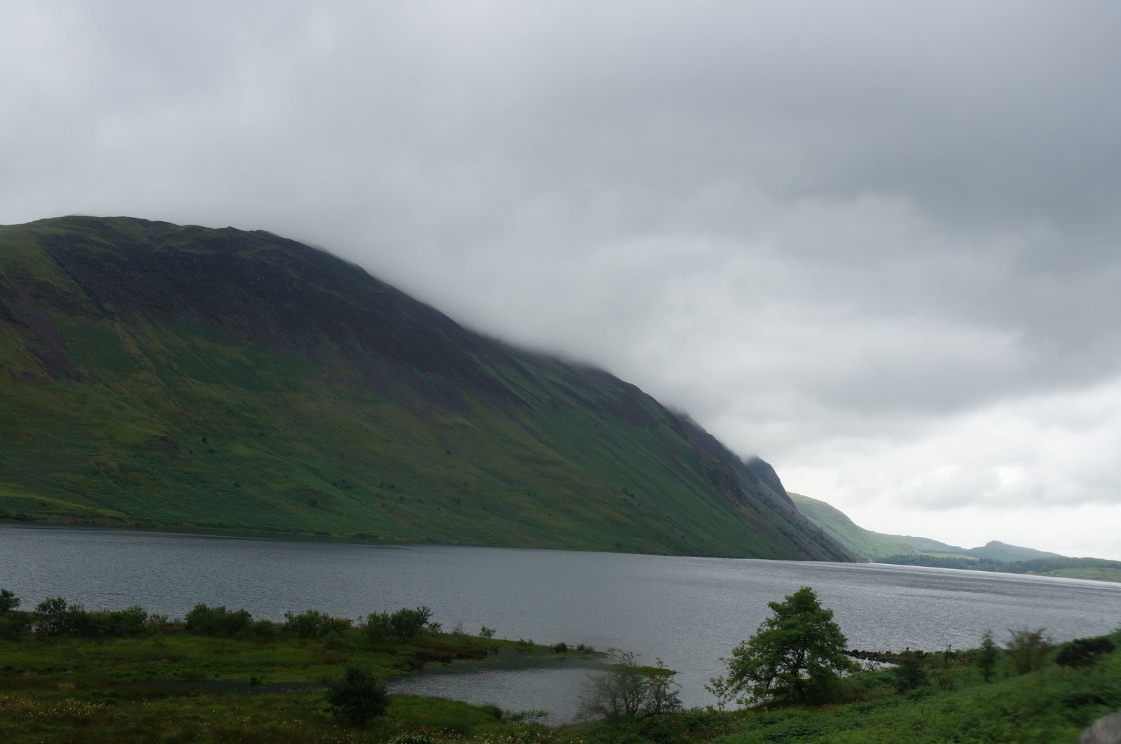
“Cumbria Way” trail. Sheep dotted
bright green pastures bordered by loose stone walls shot up the hillside to our
left as Stonethwaite Beck (a beck, by the way, is a stream or river running through a valley) bubbled away on our right.
I found myself grateful for my gortex lined boots right away as the tiny
streams coming off the fells. A
“fell is elevated ground flooded
across the stone path. I found The ridges and rocks of the Barrowdale Fells on
our right and Greenup Edge on our left gradually became more pronounced.

 At Smithymire Island, our way diverged from the Cumbria Way
path and led upwards toward Greenup Edge.
The higher we climbed the more challenging the trail grew eventually
turning into a steep scramble up the rocks leading to Lining Crag - a blustery
stone outcrop with beautiful views of the green valley we’d just come
through. We huddled down among the
rocks for some protection from the wind and munched happily on our enormous
packed lunches.
At Smithymire Island, our way diverged from the Cumbria Way
path and led upwards toward Greenup Edge.
The higher we climbed the more challenging the trail grew eventually
turning into a steep scramble up the rocks leading to Lining Crag - a blustery
stone outcrop with beautiful views of the green valley we’d just come
through. We huddled down among the
rocks for some protection from the wind and munched happily on our enormous
packed lunches.
From Lining Edge we continued our upward track to
Greenup-Edge on a better trail, and from their climbed our way to the Low White
Stones, the High White stones, then across the boggy highlands to the summit of
High Raise (762 m).
 |
| Cairn (man made pile of stones) at the top of High Raise |
After a short
huddle in the wind shelter constructed of a short storm wall where we chatted
with two gentlemen also on their way to Langdale, and consulted our
instructions and map, we set off again.
As the gentlemen (a good deal faster than we were) slowly faded into the
distance, the path grew boggier and finally disappeared altogether. I pulled out
my compass and attempted to guide us in more or less the correct direction
while looking for markers for the path to Dungeon Gill. I again found myself grateful for a
good pair of boots as more than once I stepped into boggy muck that rose to my
ankles before relinquishing its hold with a satisfying squelch.
As we reached the top of a rise of
whitish stones, I noticed a group of hikers a short distance below. I trotted down the stone-speckled
grassy hillside to catch them.
“Hello” I said to the first hiker, youngish a middle aged,
thin man in brown trousers and a pullover sweater.
“Hi” He replied.
“Excuse me I said, - my friends and I are having some
trouble locating the trail to Dungeon Ghyll. I was wondering if you happened to know that trail.
“I’m sorry, I have no Idea, you should ask Ian, our guide.”
He said, indicating another man a few meters off.
“Thanks.” I said, as I turned toward Ian.
“Where are you heading?” Ian asked,
“Dungeon Ghyll” I replied, “we lost the path in the bog.”
“Yeah, the path gets a bit…ambiguous up here.” He replied. “What
you want to do is head around those rocks over there and the path should become
clear once you get round to the other side.”
“Great, thanks so much!” I said, then turned and bounded
back up the hillside with energy that surprised even me. For a brief moment, I felt like Lizzy
Bennett running her cares away in the English Countryside.
I related the news to the others and we began heading in the
direction of the mound of rocks that Ian indicated.
“If we find the trail on the other side of these rocks, I’m
going to sit down and celebrate with some M&M’s” I told Amy. “And if we
don’t find the trail on the other side of these rocks, we’ll first look on the
other side of those rocks, and then, at the moment I’m most frustrated, we’ll
sit down and have some M&M’s because the world always looks better when
you’ve eaten some M&M’s.
When we reached the rock, a rock trail appeared, almost as
if by magic. True to my word, we
sat down and took a few moments to munch on M&M’s and trail mix before
beginning down the trail. As a
wise young woman once observed: “food always tastes better in the out of
doors,” and those M&M’s tasted heavenly.
 |
| Stickle Tarn |
 |
| Stickle Ghyll |
The trail down the mountain was more challenging than the
description in our guide made it sound.
It was steep and the scree that covered the trail in so many places made
it difficult keep footing. There
were many places where we had to scramble, to sit and slide, or to hug the
cliff wall in order keep our footing.
Every 50 meters seemed to take an eternity and by the time we reached
Stickle Tarn (a tarn is a mountain lake or pool formed in a hollow formed by a glacier) and
started down the stairs, my muscles and mind were both tired from the
effort.
Perhaps at this point in
the story it might be worth mentioning that we never actually found the path
down Dungeon Ghyll. Dungeon Ghyll
is a steep and deep ravine that hides a stunning water fall. The path we found also led to a
spectacular cascade of water, but this cascade is called “Stickle Ghyll” (a ghyll by the way is a stream or narrow valley containing a stream). The path we were on, however matched the description in our
guide to the letter, and fortunately ends at the same point as the Dungeon Ghyll path.
About 100
meters into our descent of Stickle Ghyll the trail seemed to disappear. At almost the same moment, I noticed a
parallel trail that seemed to be in better repair running along the other
side. I mentioned this to my
companions and they pointed out that several people had crossed the
cascade. At that same moment, we
watched two hikers descend to the cascade, step from rock to rock in the raging
torrent to reach the trail on the opposite side.
“So we can climb up and cross the dam, or we can try to
cross the waterfall.” The vote fell to the waterfall. And so, one by one, we
stepped across the slick, wet stones of Stickle Ghyll to the path on the other side.
 |
| Waterfalls at the bottom of Stickle Ghyll |
The rest of the descent was a blur. We reached the bottom, followed the
directions in our guide to the hotel, discovered we’d been booked at a
different hotel (a mile and a half back down the road we’d just walked). Ate dinner at the Old Dungeon Ghyll Hotel, and walked back down the road to
the Robinson Place Farm B&B where we were greeted by Vicky who had these
words of warning: “you’ll have to dook. If I see big red marks across your
forehead in the morning, I’ll know ya forgot to dook.” So with, tired muscles, bellies full of English pub food, and Vicky's warning ringing in our ears, we went to bed.
 |
| The little white house is the Robinson Place Farm B&B |
...To be continued.

 The final part of our trip to the UK was in Scotland and mostly in Edinburgh. On Tuesday we traveled from Penrith station in the Lake district up to Ediburgh. The train was only three cars long, and this being the middle of "the Festival" (The Edinburgh Fringe Festival along with several others), the train was standing room only. I passed the trip along with seven other people and at least ten suitcases standing by the doors. Just when I thought no one would even think about trying to get on at our door, a family with a young mother, her seven or eight year old daughter, a large suitcase, and a stroller with an infant climbed in as the rest of us frantically tried to rearrange the suitcases that filled the area in order to accommodate them.


 Thursday and Friday I spent in Edinburgh, exploring the city and partaking in little parts of the Free Fringe. The Fringe Festival and the Free Fringe bring thousands of actors, comedians and musicians into town, and for a donation (or not) you can buy a beer at almost any old city pub and catch a comedy act at almost any time of the day. Street acts fill High Street and Grassmarket, some of them are high school or college vocal ensembles in Scotland to perform at the Fringe, others are comedians cutting their teeth. One balloon sculptor would throw a rubber chicken at people who walked away from his act. An australian comedian and unicycle rider would introduce passersby as his "Father," ("that's not mum, dad"), agent, ex-wife ("it's over, honey") and drug dealer. He had the crowd in stitches as he waved at every passing tourist bus and invited participation from the crowd and those who walked by - all of this before he got on his 9 foot unicycle and juggled fire.